 Where is Jibacoa?
Jibacoa (aka Playa Jibacoa) is a fishing village located on the northern coast of Cuba, at the mouth of Rio Jibacoa (Jibacoa River) in the province of Mayabeque. The Jibacoa beach-resort is 62 km (38 mi) east of the capital city of Havana, and 86 km (53 mi) west of the Varadero beach-resort. Jibacoa is part of the Santa Cruz del Norte municipality which is about 10 km west of Jibacoa.
The area includes several stretches of beach which are backed by cliffs and green hills. The hotels and resorts are located on "Playa Arroyo Bermejo" and "Playa Jibacoa"; visit our Beaches page for more information on the different beaches of this region.
The closest airports from Jibacoa are the Varadero Juan Gualberto Gomez International Airport (located near Matanzas) and the Havana Jose Marti International Airport (located west of Havana).
- From Varadero Airport (VRA) to Playa Jibacoa: 60 km (37 mi), approximately 1 hour
- From Havana Airport (HAV) to Playa Jibacoa: 80 km (50 mi), approximately 1 hour 15 min.

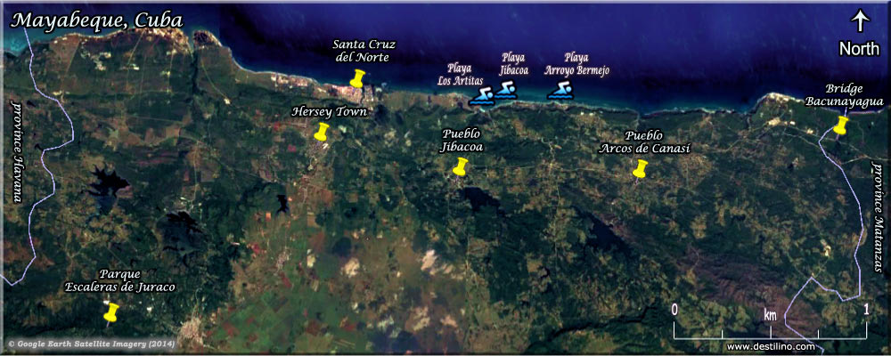 Here's an aerial view of Jibacoa showing the location of the hotels, beaches, and other points of interest and an aerial view of the Jibacoa region showing the location of villages, towns and other points of interest
The Mayabeque province is one of two new provinces in Cuba, whose creation was approved by the Cuban National Assembly on August 1st, 2010. The western provinces of Cuba have been modified. The former province of “La Habana” (rural part) is now named “Mayabeque”. Its size as well as “Pinar del Rio” has been reduced to create a new province called “Artemisa”. The province of “Ciudad de la Habana” (city part) remains the same in size but recovered its original name “La Habana". Mayabeque covers an area of 3,733 km2 (1441 sq.mi) with 381,446 inhabitants; it contains 11 municipalities and its capital is San José de las Lajas. Click to see a Distance Chart between some major Cuban cities.
© Google Earth. Click or move your mouse pointer over the markers to view description. Click & Drag to change map area and see other points of interest in the region. Zoom in or out using the + and - buttons or your mouse's wheel.
Lily & Normand
© jibacoacuba.net
© destilino.com